Geography, 26.06.2019 02:00 adrianaglass12
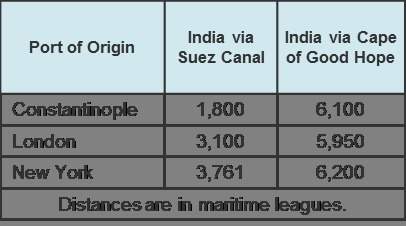
Background information: this chart shows the distance between three cities and india via two routes: the suez canal and around the cape of good hope of africa. use the drop-down menus to complete the statements. ~ 1) using the canal, the distance between london and india is maritime leagues. a) 1,800 b) 3,100 c) 3,761 d) 5,950 2) to sail from new york to india around the cape of good hope in africa, one would have to travel maritime leagues. a) 1,800 b) 3,761 c) 5,950 d) 6,200 3) a ship traveling from constantinople would save leagues by taking the canal instead of sailing around africa. a) 1,800 b) 4,300 c) 6,100 d) 6,200


Answers: 1


Another question on Geography

Geography, 22.06.2019 16:30
What do the capital cities of lebanon, kuwait, qatar, united arab emirates, and oman have in common? they are all inland cities. they are all coastal cities. they are all have “stan” in their names.
Answers: 2

Geography, 22.06.2019 23:00
Trade routes emerged along which coast when arab and indian traders from around the indian ocean mixed with the bantu people from africa's interior? a. swahili coast b. guinea coast c. drakensberg coast d. namib coast
Answers: 2

Geography, 22.06.2019 23:30
On nights when we see the new moon phase, what side of the moon are we seeing?
Answers: 2

Geography, 22.06.2019 23:30
Which of the following best describes brazil's economy from 1650-1880? a. it gradually shifted to manufacturing as the industrial revolution progressed. b. it was based on mining. c. it was based on plantation agriculture, where slaves served as a labor force. d. it was based on small, family-owned farms.
Answers: 2
You know the right answer?
Background information: this chart shows the distance between three cities and india via two routes...
Questions

Social Studies, 28.06.2019 16:30


Biology, 28.06.2019 16:30

Chemistry, 28.06.2019 16:30


Mathematics, 28.06.2019 16:30

Mathematics, 28.06.2019 16:30


English, 28.06.2019 16:30


English, 28.06.2019 16:30


English, 28.06.2019 16:30


Health, 28.06.2019 16:30


