Nalyze the map below and answer the question that follows.
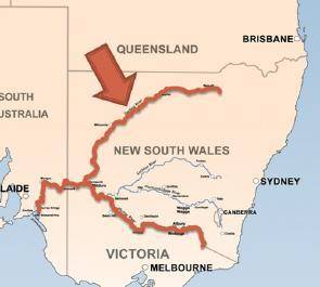
A political map of southeaste...

Geography, 12.03.2020 20:36 antojustice
Nalyze the map below and answer the question that follows.
A political map of southeastern Australia. Areas labeled from top to bottom are Queensland, New South Wales, and Victoria. The Murray River splits along the border of Victoria and New South Wales. An arrow points to the northern river split in New South Wales.
Image by Bidgee
Which body of water is the arrow on the map above pointing to?
A.
the Murray River
B.
the Darling River
C.
the Waikato River
D.
Sunderland Falls
Please select the best answer from the choices provided
A
B
C
D

Answers: 3


Another question on Geography
Geography, 22.06.2019 05:40
Which best explains why england had the highest standard of living in the world in 1990? a.england started industrializing before the rest of the world b.england had the highest population in the world. c.england hadthe most fertile soil in the world. dengland had more natural resources.
Answers: 3
Geography, 24.06.2019 08:00
Amountain range known as the southern alps runs through the center of the south island. what type of mountains do you think the southern alps are? explain your answer. .
Answers: 2
Geography, 24.06.2019 17:30
Which contenents can easily trade by traveleing the meddetaranian sea
Answers: 1
You know the right answer?
Questions

Chemistry, 26.06.2020 16:01

Mathematics, 26.06.2020 16:01
Mathematics, 26.06.2020 16:01

Mathematics, 26.06.2020 16:01

History, 26.06.2020 16:01
Mathematics, 26.06.2020 16:01
Mathematics, 26.06.2020 16:01
English, 26.06.2020 16:01
Mathematics, 26.06.2020 16:01
Mathematics, 26.06.2020 16:01

Mathematics, 26.06.2020 16:01


