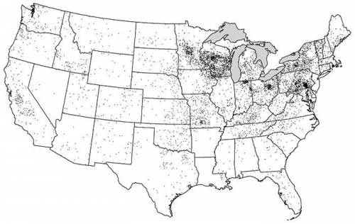
A. Identify ONE type of boundary data shown on the map.
B. Identify the region of the Un...

Geography, 09.04.2020 08:16 katherineweightman
A. Identify ONE type of boundary data shown on the map.
B. Identify the region of the United States where most dairy farms are located.
C. Identify ONE spatial pattern shown on the map.
D. Describe the characteristic land use associated with the spatial pattern shown on the map.
E. Describe TWO geographic features not shown on the map that would help explain the patterns of dairy farming shown on the map.

Answers: 1


Another question on Geography
Geography, 23.06.2019 05:00
Triangle xyz is translated 4 units up and 3 units left to yield triangle x'y'z' what is the distance between any two corresponding points on triangle xyz and trianglex'y'z' ?
Answers: 2
Geography, 23.06.2019 07:00
Which season occurs in the northern hemisphere when the sun is at its lowest point in the sky
Answers: 2
Geography, 23.06.2019 15:30
What is unusual about the iraq mountains ,in spite of their old age?
Answers: 1
Geography, 23.06.2019 17:00
Which of the following types of tourist are best to bring money to the local southeast asian communities
Answers: 1
You know the right answer?
Questions


Spanish, 24.04.2020 00:57


Social Studies, 24.04.2020 00:57

Mathematics, 24.04.2020 00:57


English, 24.04.2020 00:57
Mathematics, 24.04.2020 00:57

Biology, 24.04.2020 00:57
History, 24.04.2020 00:57
History, 24.04.2020 00:57


