can anyone help me figure this out ?
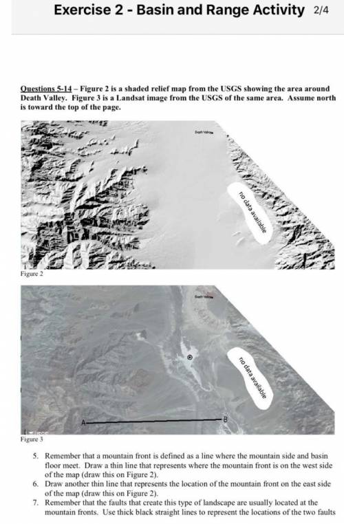
Figure 2 is a shaded relief map from the USGS showi...

Geography, 25.06.2020 04:01 kparker7543
can anyone help me figure this out ?
Figure 2 is a shaded relief map from the USGS showing the area around
Death Valley.
Figure 3 is a Landsat image from the USGS of the same area.
Assume north
is toward the top of the page.

Answers: 1


Another question on Geography
Geography, 22.06.2019 22:00
Why have the countries of the region had difficulty establishing democratic governments in recent years? choose all answers that are correct b is also correct i need to know if theres any morecommunists have overtaken the countries of the caucasus region. the soviets established national borders in the region without considering the location of ethnic groups. fighting continues between armenia and azerbaijan over the nagorno-karabakh region. civil war between communists and islamic groups in tajikistan resulted in thousands of deaths and refugees are forced to flee. in a test!
Answers: 1
Geography, 23.06.2019 00:00
Match the following items. 1 1 (4,4) 2. (-4,-2) 3. (3.-6) 4. (-4, 6) 5. (1,5)
Answers: 1
Geography, 23.06.2019 09:30
From the standpoint of geography,a is an internal rendering of an individual's known world
Answers: 3
Geography, 23.06.2019 19:00
What is likely to happen in the long term if the earth continues to absorb more energy than it emits? a. the earth will discontinue recycling energy. b. organisms will begin to compensate for the change by incorporating more energy. c. the overall temperature of the earth will increase. d. the nutrient cycles will happen more frequently. select the best answer from the choices provided a b c d
Answers: 1
You know the right answer?
Questions

Health, 02.08.2019 21:00

Mathematics, 02.08.2019 21:00

World Languages, 02.08.2019 21:00
Mathematics, 02.08.2019 21:00

History, 02.08.2019 21:00
Mathematics, 02.08.2019 21:00
History, 02.08.2019 21:00
History, 02.08.2019 21:00

Mathematics, 02.08.2019 21:00
Mathematics, 02.08.2019 21:00
History, 02.08.2019 21:00
Mathematics, 02.08.2019 21:00

Mathematics, 02.08.2019 21:00


Social Studies, 02.08.2019 21:00


