
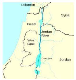
A cartographic map of countries around the Jordan River and the Dead Sea. Clockwise, countries labeled are Lebanon, Syria, Jordan, West Bank, and Israel.
Image courtesy of the UN Cartographic Section
According to the map above, which countries are likely to be dependent upon the Jordan River for their water resources? How might this lead to conflict?

Answers: 3


Another question on Geography
Geography, 23.06.2019 04:20
Determine which of the two measurements in each set is lesser.10°f or 20°ca. 10-fb. 20°c
Answers: 1
Geography, 23.06.2019 17:30
What factors of japan’s geography make it necessary for it to import so many goods?
Answers: 1
Geography, 23.06.2019 18:00
Which ecosystem best fits the characteristics listed below? which ecosystem best fits the characteristics listed below? ii. seasonal migrations of millions of wildebeests, zebras, and elephants iii. large numbers of predators, such as lions iv. acacia trees and grasses a. the congo rainforest b. the african mangroves c. the serengeti grasslands d. the sahel
Answers: 1
Geography, 23.06.2019 21:40
Directions you probably already know that people have different ways to organize their ideas. some people make lists or outlines, some draw pictures, while others may combine these two methods. experiment with different note-taking techniques to find the one which works best for you. one common note-taking technique is webbing. webbing uses the sizes of circles to indicate the importance of items. lines are used to indicate the relationships between items. the example below is based on the information presented in a previous lesson. notice that the circle for "geography is" appears at the center of the web. it has larger than the circles that surround it. the "geography " circle is surrounded by smaller circles of earth's atmosphere, earth's climate, earth's surface. notice the lines that connect these items to the concept of geography. notice that the circles surrounding atmosphere are smaller. also observe that the lines that connect the items and indicate the relationships between the items. webbing will you capture the most important points in your lessons. beginning with lesson two, geographic tools: globes and maps, use webbing to take notes on the important information in this unit. hint: it will be easier to complete this project if you take your notes after completing each lesson.
Answers: 1
You know the right answer?
A cartographic map of countries around the Jordan River and the Dead Sea. Clockwise, countries label...
Questions

Mathematics, 19.08.2019 02:30

Physics, 19.08.2019 02:30
Mathematics, 19.08.2019 02:30


Chemistry, 19.08.2019 02:30
English, 19.08.2019 02:30

Mathematics, 19.08.2019 02:30


Social Studies, 19.08.2019 02:30
Mathematics, 19.08.2019 02:30
Mathematics, 19.08.2019 02:30
History, 19.08.2019 02:30


