
Geography, 09.12.2020 09:10 jjmarie612
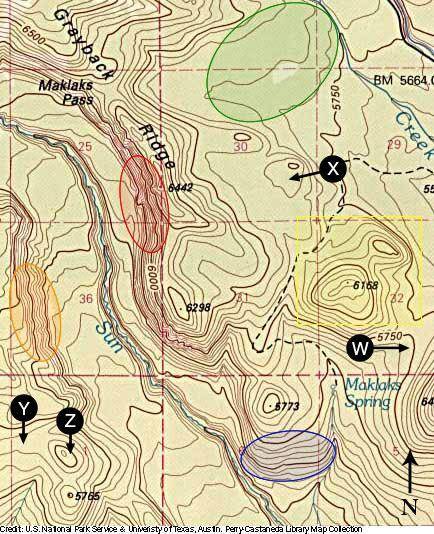
1) What is the contour interval?
2) In what direction is Maklaks Spring flowing (downstream)? How can you tell?
3) Which area is most steep of the areas enclosed in red, blue, green, or orange circles? How can you tell?
4) If you were standing on the east side of the feature that has its highest point of elevation at 6,168 (shown in the yellow square box), what graphic would most represent the shape or profile of the geographical feature?
5) Provide an approximate elevation for points W, X, Y, and Z (Z is pointing right to the line).

Answers: 3


Another question on Geography
Geography, 23.06.2019 03:30
Select the word from the list that best fits the definition a mountain range in northeast central asia answer is altay shan
Answers: 1
Geography, 23.06.2019 21:30
In an effort to japan recover from the devastating effects of the 1929 depression, japanese military leaders in the 1930s formed an alliance with nazi germany negotiated more trade treaties with the soviet union closed its doors to western trade adopted a policy of imperialist expansion
Answers: 2
Geography, 24.06.2019 02:30
Which of the following characteristics define a state? check all that apply. a. a population of people b. a sovereign government that determines how a group of people is ruled c. an army, military, or police force d. a territory with set borders
Answers: 1
You know the right answer?
1) What is the contour interval?
2) In what direction is Maklaks Spring flowing (downstream)? How c...
Questions


Arts, 09.09.2020 23:01

Spanish, 09.09.2020 23:01


Mathematics, 09.09.2020 23:01


Physics, 09.09.2020 23:01
Mathematics, 09.09.2020 23:01
Mathematics, 09.09.2020 23:01


