
Geography, 21.12.2020 20:40 monsterduckgoose
Analyze the image below and answer the question that follows.
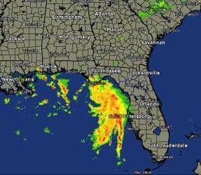
A map of the Southeastern U S used for weather forecasting.
Image courtesy of the National Weather Service
Analyze the image above. Which remote sensing technology uses radio waves to observe and predict weather?
A. aerial photography
B. radar
C. GIS
D. GPS
Please select the best answer from the choices provided
A
B
C
D

Answers: 3


Another question on Geography
Geography, 22.06.2019 15:50
How does a command economy differ from a mixed market economy? in a command economy, citizens have fewer property rights. in a mixed market economy, citizens have more property in a command economy, citizens have more property rights. in a mixed market economy, citizens have fewer property rights in a command economy citizens own all public property. in a mixed market economy, the government owns all private, property in a command economy, citizens own all private property in a mixed market economy, the goverment owns all public property
Answers: 1
Geography, 22.06.2019 22:30
At which point on the diagram do convection currents occur to drive plate movement?
Answers: 1
Geography, 23.06.2019 13:30
Quiero una redaccion de yo soy medico y que tenga 10 lineas
Answers: 2
Geography, 23.06.2019 13:30
What border separates sonora and chihuahua national border state border physical boundary natural boundary
Answers: 1
You know the right answer?
Analyze the image below and answer the question that follows.
A map of the Southeastern U S used...
Questions


Mathematics, 25.01.2022 08:50
Mathematics, 25.01.2022 08:50
Mathematics, 25.01.2022 08:50
Mathematics, 25.01.2022 08:50


Geography, 25.01.2022 08:50
Mathematics, 25.01.2022 08:50


Chemistry, 25.01.2022 08:50


