
Geography, 09.09.2021 23:00 Albraaalouda
HELP
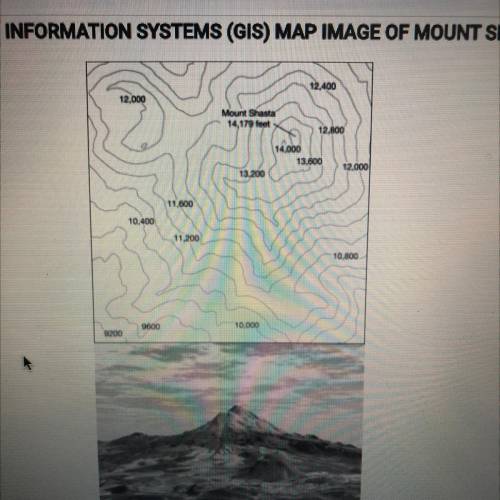
The images show a topographic map and a geographic information systems parentheses GIS parentheses representation of mount Shasta in California. Which of the following statements best explains why these printed images are geometrically distorted representations of earths surface?
A Some maps do not show the actual coloration of earths surface and vegetation
B GIS can only display two dimensional layers
C The planets gravitational poles are not located at the poles of earths axis
D three dimensions of earths surface are displayed on two dimensional page
E printed Maps alter the sense of place that people can have about a location

Answers: 1


Another question on Geography
Geography, 22.06.2019 02:00
Describe the events that led to the partition of india, and explain the consequences of this event.
Answers: 1
Geography, 22.06.2019 13:30
What was one effect of european influence on southeast asia? new roads and railroads were constructed. rulers built palaces in the european architectural style. the vietnamese absorbed much of the european culture. the islamic religion spread throughout the region.
Answers: 2
Geography, 23.06.2019 07:30
Brazilians, like the u.s., communicate directly and you have to be careful with the use of slang. their communication style is a.low-context b. high-context
Answers: 1
Geography, 24.06.2019 05:00
The us labor movement began in the a. 1930s b. 1920s c. 1880s d. 1860s select the best answer from the choices provided. a b c d
Answers: 1
You know the right answer?
HELP
The images show a topographic map and a geographic information systems parentheses GIS parent...
Questions

Mathematics, 08.05.2021 18:30

Mathematics, 08.05.2021 18:30
Mathematics, 08.05.2021 18:30


Mathematics, 08.05.2021 18:30
History, 08.05.2021 18:30
Mathematics, 08.05.2021 18:30

Mathematics, 08.05.2021 18:30


