Use the physical map of Europe below to answer the following question:
A physical map of...

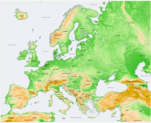
Use the physical map of Europe below to answer the following question:
A physical map of Europe showing its topography, or elevation. Areas shaded brown refer to highlands and mountains. Brown areas include most of Spain, southeastern France, northern and central Italy, Switzerland, Austria, Slovenia, Bosnia, Montenegro, Serbia, southeastern Germany, Czech Republic, Slovakia, Greece Turkey, parts of Romania, parts of Bulgaria, Iceland, Norway, and western Sweden. Green shaded areas refer to lowlands or plains. Green areas include western Portugal, coasts of Spain, most of France, United Kingdom, central and northern Germany, the western and eastern coasts of Italy, Poland, Hungary, Ukraine, parts of Romania, and parts of Bulgaria.
Creative Commons Attribution-Share Alike 3.0 Unported
In which of the following locations would you expect to find the highest population density per square mile?
The Italian coast
Central Spain
Western Russia
Northern Scandinavia

Answers: 2


Another question on History
History, 21.06.2019 17:30
Many city governments grant operating licenses to a specific cable television company
Answers: 2
History, 22.06.2019 03:30
Which statement best summarizes how interpreted in very strict terms government have changed over time
Answers: 1
History, 22.06.2019 04:00
Which of the following statements best describes the importance of the battle of
Answers: 1
History, 22.06.2019 07:00
In 1991, which of the following split into 15 independent republics when its communist government lost power? a) china b) belarus c) germany d) soviet union
Answers: 2
You know the right answer?
Questions


Computers and Technology, 21.09.2020 14:01


Mathematics, 21.09.2020 14:01
Mathematics, 21.09.2020 14:01


Social Studies, 21.09.2020 14:01
Mathematics, 21.09.2020 14:01
Mathematics, 21.09.2020 14:01
Mathematics, 21.09.2020 14:01
Mathematics, 21.09.2020 14:01
History, 21.09.2020 14:01


